

This repo is a research of IPFS-GEO (a geography relation object model demo with ipfs). Feel free to star and fork.
Any comments, suggestions? Let us know!. We love PRs :) Please take a look at the Contributing guidelines before opening one.
This project goal is to build a relation pattern with position information and block chain. Implement a ecological model for people->position->real world->transfer trust->transfer worth->position->people and use block chain to index real world.
-
DDApp(Data Decentered Application): For resolve DApp can't rely on the center API, DDApp is a new concept that only the data is decentration. This concept not only can communicate with each other, but also can deploy independent and support p2p transfer.
-
IPFS(InterPlanetary File System): An distributed file system.
-
GeoHash: The algorithm can greater increase the searching efficiency in large position data, and support convenient cache for app.

| property | type | comment |
|---|---|---|
| geo_id | INT | uniqueness identification |
| geo_address | STRING | address |
| geo_lng | FLOAT | longitude |
| geo_lat | FLOAT | latitude |
| geo_hash | STRING | geo hash, created by position |
| ipfs_hash | STRING | ipfs hash, created by saving data |
| addGeoInfoByParam() | FUNCTION | add position message |
| getGeoInfoByParam() | FUNCTION | get position message |
| mixGeoHashByParam() | FUNCTION | get GeoHash |
| addIpfsDataByParam() | FUNCTION | add ipfs data |
| mixIpfsHashByParam() | FUNCTION | associate ipfs data |
There is a test report of search 1 million poi data by some friends.
| Database Name | Proc Time | Support Regional Search | Support Multi Condition | |
|---|---|---|---|---|
| redis(3.2.8) | 1-10ms | yes | no | |
| mongo(3.4.4) | 10-50ms | yes | yes | |
| postgreSQL(9.6.2) | 3-8ms | yes | yes | |
| mysql(5.7.18) | 8-15ms | yes | yes |
compare these statistics data, I chose MySql to support the geo system demo.
- Older than MySql 5.7.4, the
myISAMengine hasGeomto implement this function. - Newer than MySql 5.7.4,
InnoDBengine also support for space index.
PS:
-
- Not the best database, only have the suit database.
-
- Researching the storage effiency, since the network node is test now and so instability that there have serious slow problem of transmission data, we can't reach
high frequency to updateandmillions of data to indexon IPFS.
- Researching the storage effiency, since the network node is test now and so instability that there have serious slow problem of transmission data, we can't reach
-
- Maybe we should find a efficiency plan to use IPFS under the current situation now.
-- table struct `geo_object`
--

CREATE TABLE `geo_object` (
  `geo_id` bigint(20) NOT NULL  AUTO_INCREMENT,
  `geo_loc` point NOT NULL,
  `geo_address` varchar(255) NOT NULL,
  `ipfs_hash` varchar(255) NOT NULL
) ENGINE=MyISAM DEFAULT CHARSET=utf8 COMMENT='geo object model';

-- Indexes for table `geo_object`
ALTER TABLE `geo_object`
  ADD PRIMARY KEY (`geo_id`),
ADD SPATIAL KEY `geo_loc` (`geo_loc`);Base on these concept and design model above, now we can implement a simple demo:
-
The detail of deploy a single node of ipfs can refer to use ipfs to build a decentration wiki system
-
Now the official support
curlmethod, we can useaddIpfsDataByParam()to implement RPC.curl -F file=@myGeoFile "http://localhost:5001/api/v0/add?recursive=false&quiet=false&hash=sha2-256" -
PS: This demo use location node to upload data, for protect the service available, we suggest use ipfs-cluster and the detail can refer to the article ipfs family II.
The response data is 'multipart/form-data' type. If success, these data would be recived:
{
    "Name":"myGeoFile"
    "Hash":"QmYftndCvcEiuSZRX7njywX2AGSeHY21Sa7VryCq1mK1Ew"
    "Bytes":"2428803"
    "Size": ""
}
After get the hash, we can use mixIpfsDataByParam() function to relate our Geo position data.
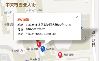
- latitude: 39.989049
- longitude: 116.313658
INSERT INTO `geo_object`(`geo_loc`, `geo_address`, `ipfs_hash`) VALUES (GeomFromText('POINT(39.989049 116.313658)'),'3W Coffee','QmYftndCvcEiuSZRX7njywX2A21Sa7VryCq1mK1Ew21')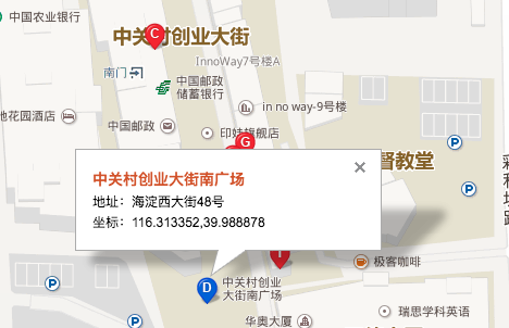
-
latitude:39.988878
-
longitude:116.313352
INSERT INTO `geo_object`(`geo_loc`, `geo_address`, `ipfs_hash`) VALUES (GeomFromText('POINT(39.988878 116.313352)'),'Sourth Street of Zhong Guan Village','WCJIEFSCvcE231233HY21Sa7Vr1Cq1mK1Ew')
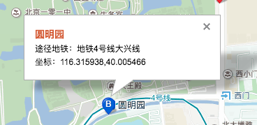
- latitude:40.005466
- longitude:116.315938
INSERT INTO `geo_object`(`geo_loc`, `geo_address`, `ipfs_hash`) VALUES (GeomFromText('POINT(40.005466 116.315938)'),'Old Summer Palace','KBYftndCvcEiuSZRX7njyw1332Y21Sa723mKASDED')Assume the diagonal points of sphere fence is A1(x1, y1), B1(x2, y2):
x1 = lat + distance / ( 111.1 / COS(RADIANS(lng))),
y1 = lng + distance / 111.1

x1 = lat - distance / ( 111.1 / COS(RADIANS(lng))),
y1 = lng - distance / 111.1

// build the first order space filling curve
LineString(A1,B1)
PS:
-
- One longitude of the equator is about equal 111.1km.
-
- RADIANS() is a function to compute radians.
-
- LineString() is a function to build the first order space filling curve.
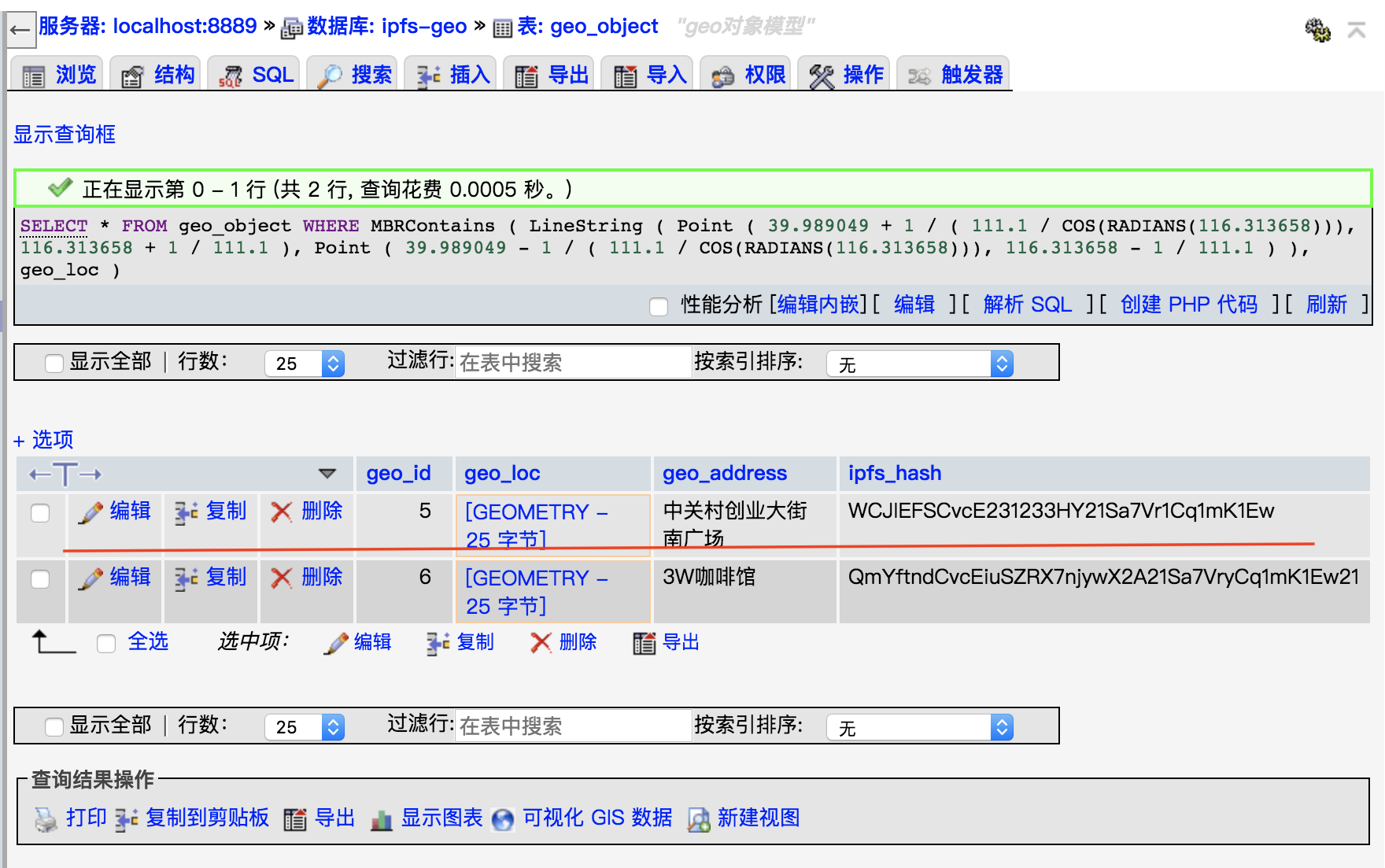
SELECT  *
    FROM    geo_object
    WHERE   MBRContains
                    (
                    LineString
                            (
                            Point
                                    (
                                    39.989049 + 1 / ( 111.1 / COS(RADIANS(116.313658))),
                                    116.313658 + 1 / 111.1
                                    ),
                            Point
                                    (
                                    39.989049 - 1 / ( 111.1 / COS(RADIANS(116.313658))),
                                    116.313658 - 1 / 111.1
                                    )
                            ),
                    geo_loc
                    )
As shown in the following figure, we get the ipfs data within 1 km distance of 3W Coffee
SELECT  *
    FROM    geo_object
    WHERE   MBRContains
                    (
                    LineString
                            (
                            Point
                                    (
                                    39.989049 + 10 / ( 111.1 / COS(RADIANS(116.313658))),
                                    116.313658 + 10 / 111.1
                                    ),
                            Point
                                    (
                                    39.989049 - 10 / ( 111.1 / COS(RADIANS(116.313658))),
                                    116.313658 - 10 / 111.1
                                    )
                            ),
                    geo_loc
                    )
As shown in the following figure, we get the ipfs data within 10 km distance of 3W Coffee

PS: About this demo detail, we will write a new article to describe these.
- Vevue: A dapp to encourage user to take a picture on special location and reward some token.
- sign in by position: only arrive special location can reward some things or get some proof.
- money in store: attract people to go to some store and reward some money.
- protect parking space: protect some parking space that someone has bought.
- unite with AR game: AR game unite with position and reware some token.
- IOT: some IOT have position property, these may unite with this system.
goal: Expect everyone can realize some application scene by ipfs even block chain. Use technology to crate real value. Welcome everyone to join.
meaning: This is a intelligent IPFS object and it's meta data has Geo property and support fast index 10 millions space data. It also provides LBS function api.